Africa Map Assignment
This assignment is intended for you to learn about the nation–states of Africa. Like most of Europe, Africa is divided into independent nations with unique and individual governments. These nations are not bound by one governing body like the Federal Government of the United States; although all except Morocco participate or belong to the African Union.
The Map
Download a copy of the African Map Outline. This is a blank template that you will fill in with color and label the individual nations.

General Guidelines
Since we are fortunate enough to have an amazing Tech Lab with the latest design software (and since you've all graduated from crayons), you'll complete this map using Photoshop.
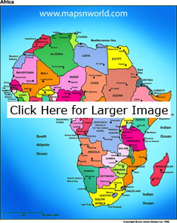
Using the map to the right as your guide, fill in the blank map with the following:
- Nation–States – label in all–caps
- Capitals – label with a star shape and use proper capitalization
- Oceans, Seas, and Lakes – fill with light blue, DO NOT USE the same light blue anywhere else
- Indian Ocean
- Atlantic Ocean
- Mediterranean Sea
- Red Sea
- Lake Nyasa
- Lake Victoria
- Lake Tanganyika
- Other Important Cities – Label with a circle shape and use proper capitalization
- Johannesburg
- Port Elizabeth
- Cape Town
- Banghazi
- Port Sudan
- Alexandria
- Constantine
- Casablanca
- Pointe–Noire
- Mombasa
- Zanzibar


